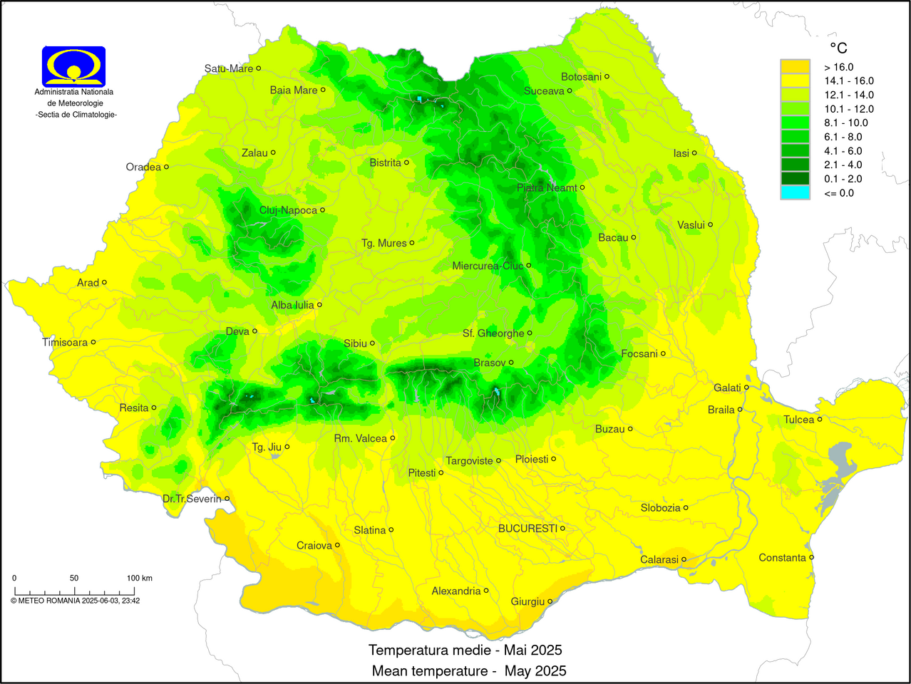
 română
 engleză
 Meteo Romania


Temperatură: 19.3 ºC
Vânt: 2.0 m/s, directia : N
Nebulozitate: indisponibil
Presiune: 1000.7 mb, in crestere
Umezeală relativă: 81%
alege stația meteo
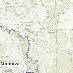
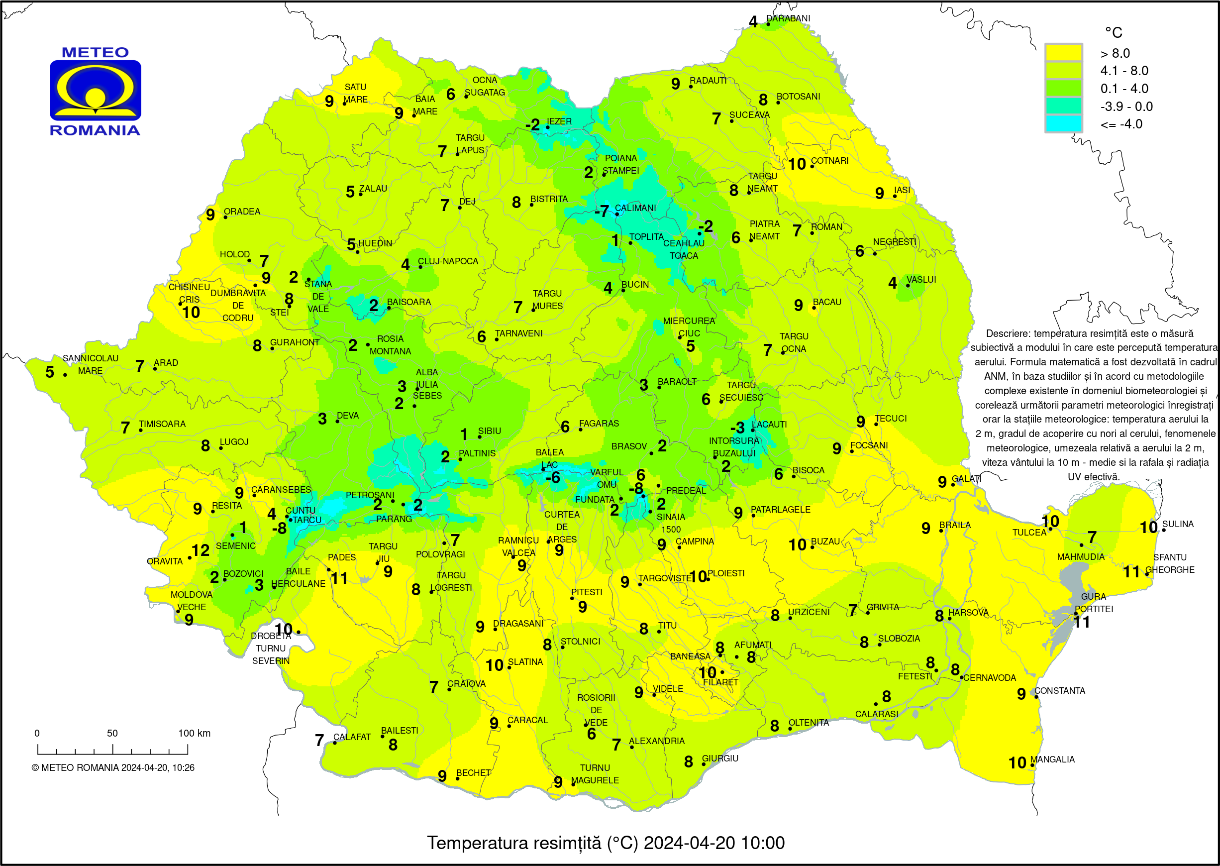
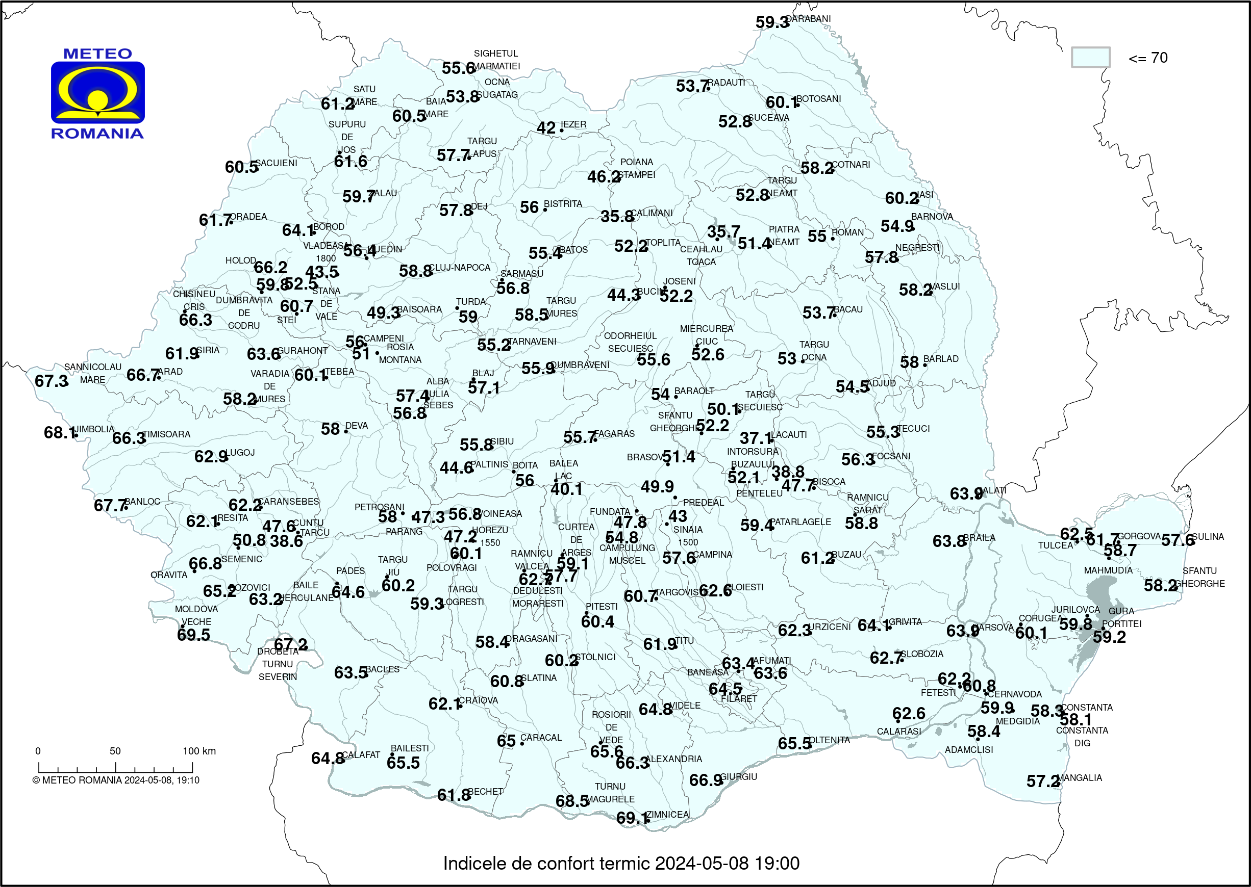
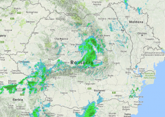
Situația meteo România: 18-06-2025 ora 05:00
ADAMCLISI
18-06-2025 ora 05:00
ADJUD
18-06-2025 ora 05:00Temperatură: 17.4 ºC
Vânt: 2.3 m/s, directia : VNV
Nebulozitate: indisponibil
Presiune: 1008.2 mb, in crestere
Umezeală relativă: 90%ALBA IULIA
18-06-2025 ora 05:00Temperatură: 16.8 ºC
Vânt: 0.4 m/s, directia : NV
Nebulozitate: indisponibil
Presiune: 991.8 mb, in scadere
Umezeală relativă: 90%ALEXANDRIA
18-06-2025 ora 05:00 Temperatură: 19.3 ºC
Vânt: 6.6 m/s, directia : E
Nebulozitate: cer senin
Presiune: 1009.6 mb, stationara
Umezeală relativă: 82%AMZACEA
18-06-2025 ora 05:00Temperatură: 17.9 ºC
Vânt: 3.5 m/s, directia : NNV
Nebulozitate: indisponibil
Presiune: 1009.0 mb, in crestere
Umezeală relativă: 82%ARAD
18-06-2025 ora 05:00Temperatură: 16.2 ºC
Vânt: 1.2 m/s, directia : NNE
Nebulozitate: cer senin
Presiune: 1007.0 mb, in scadere
Umezeală relativă: 75%BACAU
18-06-2025 ora 05:00 Temperatură: 17.7 ºC
Vânt: 0.5 m/s, directia : VNV
Nebulozitate: cer partial noros
Presiune: 1000.3 mb, stationara
Umezeală relativă: 79%BACLES
18-06-2025 ora 05:00Temperatură: 17.4 ºC
Vânt: 2.3 m/s, directia : V
Nebulozitate: indisponibil
Presiune: 982.6 mb, in scadere
Umezeală relativă: 85%BAIA MARE
18-06-2025 ora 05:00Temperatură: 13.7 ºC
Vânt: 2.0 m/s, directia : NNE
Nebulozitate: cer senin
Presiune: 998.9 mb, in crestere
Umezeală relativă: 85%BAILE HERCULANE
18-06-2025 ora 05:00Temperatură: 17.9 ºC
Vânt: 1.1 m/s, directia : NNE
Nebulozitate: indisponibil
Presiune: 997.3 mb, in crestere
Umezeală relativă: 86%BAILESTI
18-06-2025 ora 05:00Temperatură: 17.2 ºC
Vânt: 1.0 m/s, directia : VSV
Nebulozitate: indisponibil
Presiune: 1011.8 mb, stationara
Umezeală relativă: 89%BAISOARA
18-06-2025 ora 05:00Temperatură: 13.0 ºC
Vânt: 1.8 m/s, directia : SV
Nebulozitate: indisponibil
Presiune: 871.2 mb, in scadere
Umezeală relativă: 85%BALEA LAC
18-06-2025 ora 05:00Temperatură: 9.4 ºC
Vânt: 0.6 m/s, directia : SE
Nebulozitate: cer partial noros
Presiune: 801.2 mb, in scadere
Umezeală relativă: 90%
Strat zăpadă : discontinuuBANLOC
18-06-2025 ora 05:00Temperatură: 16.8 ºC
Vânt: 2.3 m/s, directia : NV
Nebulozitate: indisponibil
Presiune: 1010.9 mb, in scadere
Umezeală relativă: 84%BARAOLT
18-06-2025 ora 05:00Temperatură: 15.2 ºC
Vânt: 0.6 m/s, directia : S
Nebulozitate: indisponibil
Presiune: 961.7 mb, in crestere
Umezeală relativă: 92%BARLAD
18-06-2025 ora 05:00Temperatură: 17.6 ºC
Vânt: 1.7 m/s, directia : N
Nebulozitate: indisponibil
Presiune: 1000.2 mb, in crestere
Umezeală relativă: 72%BARNOVA (RADAR)
18-06-2025 ora 05:00Temperatură: 12.8 ºC
Vânt: 0.4 m/s, directia : NE
Nebulozitate: indisponibil
Presiune: 975.2 mb, in crestere
Umezeală relativă: 93%BATOS
18-06-2025 ora 05:00Temperatură: 13.0 ºC
Vânt: 0.4 m/s, directia : E
Nebulozitate: indisponibil
Presiune: 968.8 mb, stationara
Umezeală relativă: 92%BECHET
18-06-2025 ora 05:00Temperatură: 18.5 ºC
Vânt: 1.4 m/s, directia : VNV
Nebulozitate: indisponibil
Presiune: 1014.2 mb, stationara
Umezeală relativă: 85%BISOCA
18-06-2025 ora 05:00Temperatură: 14.2 ºC
Vânt: 5.2 m/s, directia : N
Nebulozitate: indisponibil
Presiune: 923.9 mb, in crestere
Umezeală relativă: 78%BISTRITA
18-06-2025 ora 05:00Temperatură: 14.3 ºC
Vânt: 0.9 m/s, directia : NE
Nebulozitate: indisponibil
Presiune: 977.5 mb, in crestere
Umezeală relativă: 93%BLAJ
18-06-2025 ora 05:00Temperatură: 15.9 ºC
Vânt: 1.3 m/s, directia : S
Nebulozitate: indisponibil
Presiune: 981.2 mb, in scadere
Umezeală relativă: 91%BOITA
18-06-2025 ora 05:00Temperatură: 17.1 ºC
Vânt: 0.9 m/s, directia : N
Nebulozitate: indisponibil
Presiune: 961.0 mb, in scadere
Umezeală relativă: 82%BOROD
18-06-2025 ora 05:00Temperatură: 12.9 ºC
Vânt: 2.2 m/s, directia : ESE
Nebulozitate: indisponibil
Presiune: 982.5 mb, in scadere
Umezeală relativă: 87%BOTOSANI
18-06-2025 ora 05:00Temperatură: 13.7 ºC
Vânt: 0.7 m/s, directia : V
Nebulozitate: indisponibil
Presiune: 1001.9 mb, variabila
Umezeală relativă: 82%BOZOVICI
18-06-2025 ora 05:00Temperatură: 14.3 ºC
Vânt: 0.5 m/s, directia : SSV
Nebulozitate: indisponibil
Presiune: 991.5 mb, in scadere
Umezeală relativă: 99%BRAILA
18-06-2025 ora 05:00Temperatură: 19.6 ºC
Vânt: 1.7 m/s, directia : N
Nebulozitate: indisponibil
Presiune: 1018.0 mb, in crestere
Umezeală relativă: 79%BRASOV GHIMBAV
18-06-2025 ora 05:00Temperatură: 18.5 ºC
Vânt: 2.8 m/s, directia : NV
Nebulozitate: indisponibil
Presiune: 958.6 mb, stationara
Umezeală relativă: 78%BUCIN
18-06-2025 ora 05:00Temperatură: 10.9 ºC
Vânt: 0.5 m/s, directia : E
Nebulozitate: indisponibil
Presiune: 877.0 mb, in scadere
Umezeală relativă: 96%BUCURESTI AFUMATI
18-06-2025 ora 05:00 Temperatură: 19.7 ºC
Vânt: 2.8 m/s, directia : E
Nebulozitate: cer acoperit
Presiune: 1009.8 mb, in crestere
Umezeală relativă: 71%BUCURESTI BANEASA
18-06-2025 ora 05:00Temperatură: 19.9 ºC
Vânt: 2.2 m/s, directia : ENE
Nebulozitate: indisponibil
Presiune: 1008.7 mb, in crestere
Umezeală relativă: 70%BUCURESTI FILARET
18-06-2025 ora 05:00Temperatură: 20.6 ºC
Vânt: 1.5 m/s, directia : ENE
Nebulozitate: indisponibil
Presiune: 1009.6 mb, in crestere
Umezeală relativă: 69%BUZAU
18-06-2025 ora 05:00Temperatură: 18.8 ºC
Vânt: 2.1 m/s, directia : NNE
Nebulozitate: indisponibil
Presiune: 1008.9 mb, in crestere
Umezeală relativă: 73%CALAFAT
18-06-2025 ora 05:00Temperatură: 21.3 ºC
Vânt: 2.1 m/s, directia : V
Nebulozitate: cer senin
Presiune: 1011.7 mb, stationara
Umezeală relativă: 70%CALARASI
18-06-2025 ora 05:00Temperatură: 18.5 ºC
Vânt: 1.0 m/s, directia : NE
Nebulozitate: indisponibil
Presiune: 1017.3 mb, in crestere
Umezeală relativă: 82%CALIMANI (RETITIS)
18-06-2025 ora 05:00Temperatură: 7.8 ºC
Vânt: 6.0 m/s, directia : V
Nebulozitate: cer senin
Presiune: 803.8 mb, in scadere
Umezeală relativă: 73%CAMPENI (BISTRA)
18-06-2025 ora 05:00Temperatură: 14.6 ºC
Vânt: 0.1 m/s, directia : VSV
Nebulozitate: indisponibil
Presiune: 950.7 mb, in scadere
Umezeală relativă: 95%CAMPINA
18-06-2025 ora 05:00Temperatură: 14.8 ºC
Vânt: 0.8 m/s, directia : N
Nebulozitate: indisponibil
Presiune: 966.1 mb, in crestere
Umezeală relativă: 93%CAMPULUNG MUSCEL
18-06-2025 ora 05:00Temperatură: 13.9 ºC
Vânt: 0.3 m/s, directia : VNV
Nebulozitate: indisponibil
Presiune: 942.0 mb, variabila
Umezeală relativă: 97%CARACAL
18-06-2025 ora 05:00Temperatură: 18.5 ºC
Vânt: 1.5 m/s, directia : ENE
Nebulozitate: indisponibil
Presiune: 1006.4 mb, variabila
Umezeală relativă: 79%CARANSEBES
18-06-2025 ora 05:00Temperatură: 15.6 ºC
Vânt: 0.8 m/s, directia : SE
Nebulozitate: cer senin
Presiune: 992.5 mb, stationara
Umezeală relativă: 95%CEAHLAU TOACA
18-06-2025 ora 05:00Temperatură: 7.1 ºC
Vânt: 4.5 m/s, directia : VNV
Nebulozitate: indisponibil
Presiune: 815.7 mb, in scadere
Umezeală relativă: 100%CERNAVODA
18-06-2025 ora 05:00Temperatură: 20.6 ºC
Vânt: 2.3 m/s, directia : NNE
Nebulozitate: indisponibil
Presiune: 1008.9 mb, in crestere
Umezeală relativă: 73%CHISINEU CRIS
18-06-2025 ora 05:00Temperatură: 15.4 ºC
Vânt: 2.0 m/s, directia : N
Nebulozitate: indisponibil
Presiune: 1009.5 mb, in scadere
Umezeală relativă: 78%CLUJ-NAPOCA
18-06-2025 ora 05:00Temperatură: 14.6 ºC
Vânt: 2.4 m/s, directia : SV
Nebulozitate: cer senin
Presiune: 973.2 mb, stationara
Umezeală relativă: 87%CONSTANTA
18-06-2025 ora 05:00 Fenomen : burnita
Temperatură: 21.8 ºC
Vânt: 0.9 m/s, directia : E
Nebulozitate: cer partial noros
Presiune: 1017.4 mb, in crestere
Umezeală relativă: 68%CONSTANTA - dig
18-06-2025 ora 05:00Temperatură: 22.0 ºC
Vânt: 6.7 m/s, directia : N
Nebulozitate: indisponibil
Presiune: 1018.8 mb, in crestere
Umezeală relativă: 63%CORUGEA
18-06-2025 ora 05:00Temperatură: 19.7 ºC
Vânt: 3.6 m/s, directia : N
Nebulozitate: indisponibil
Presiune: 993.6 mb, in crestere
Umezeală relativă: 63%COTNARI
18-06-2025 ora 05:00Temperatură: 17.7 ºC
Vânt: 6.9 m/s, directia : VNV
Nebulozitate: indisponibil
Presiune: 986.5 mb, stationara
Umezeală relativă: 63%CRAIOVA
18-06-2025 ora 05:00Temperatură: 20.1 ºC
Vânt: 4.7 m/s, directia : NNE
Nebulozitate: cer senin
Presiune: 996.0 mb, stationara
Umezeală relativă: 69%CUNTU
18-06-2025 ora 05:00Temperatură: 12.9 ºC
Vânt: 5.0 m/s, directia : NE
Nebulozitate: indisponibil
Presiune: 860.6 mb, in scadere
Umezeală relativă: 81%CURTEA DE ARGES
18-06-2025 ora 05:00Temperatură: 14.5 ºC
Vânt: 0.6 m/s, directia : ENE
Nebulozitate: indisponibil
Presiune: 967.3 mb, stationara
Umezeală relativă: 89%DARABANI
18-06-2025 ora 05:00Temperatură: 14.7 ºC
Vânt: 2.7 m/s, directia : VNV
Nebulozitate: indisponibil
Presiune: 990.2 mb, in crestere
Umezeală relativă: 79%DEDULESTI-MORARESTI
18-06-2025 ora 05:00Temperatură: 16.5 ºC
Vânt: 0.5 m/s, directia : N
Nebulozitate: indisponibil
Presiune: 956.5 mb, in crestere
Umezeală relativă: 80%DEJ
18-06-2025 ora 05:00Temperatură: 13.3 ºC
Vânt: 1.0 m/s, directia : N
Nebulozitate: indisponibil
Presiune: 992.9 mb, in crestere
Umezeală relativă: 90%DEVA
18-06-2025 ora 05:00Temperatură: 15.9 ºC
Vânt: 0.6 m/s, directia : SSV
Nebulozitate: indisponibil
Presiune: 992.5 mb, in scadere
Umezeală relativă: 97%DRAGASANI
18-06-2025 ora 05:00Temperatură: 21.9 ºC
Vânt: 2.6 m/s, directia : ENE
Nebulozitate: indisponibil
Presiune: 987.2 mb, variabila
Umezeală relativă: 62%DROBETA TURNU SEVERIN
18-06-2025 ora 05:00Temperatură: 20.3 ºC
Vânt: 1.3 m/s, directia : ENE
Nebulozitate: cer senin
Presiune: 1009.8 mb, stationara
Umezeală relativă: 74%DUMBRAVENI
18-06-2025 ora 05:00Temperatură: 14.2 ºC
Vânt: 0.6 m/s, directia : N
Nebulozitate: indisponibil
Presiune: 983.2 mb, stationara
Umezeală relativă: 96%DUMBRAVITA DE CODRU
18-06-2025 ora 05:00Temperatură: 15.2 ºC
Vânt: 1.4 m/s, directia : ENE
Nebulozitate: indisponibil
Presiune: 953.4 mb, in scadere
Umezeală relativă: 72%FAGARAS
18-06-2025 ora 05:00Temperatură: 17.2 ºC
Vânt: 0.7 m/s, directia : V
Nebulozitate: indisponibil
Presiune: 971.0 mb, in crestere
Umezeală relativă: 93%FETESTI
18-06-2025 ora 05:00Temperatură: 20.9 ºC
Vânt: 3.4 m/s, directia : NE
Nebulozitate: indisponibil
Presiune: 1012.6 mb, in crestere
Umezeală relativă: 65%FOCSANI
18-06-2025 ora 05:00Temperatură: 20.1 ºC
Vânt: 1.3 m/s, directia : NV
Nebulozitate: indisponibil
Presiune: 1014.3 mb, in crestere
Umezeală relativă: 71%FUNDATA
18-06-2025 ora 05:00Temperatură: 12.4 ºC
Vânt: 1.0 m/s, directia : NNE
Nebulozitate: cer senin
Presiune: 869.4 mb, in scadere
Umezeală relativă: 95%GALATI
18-06-2025 ora 05:00Temperatură: 19.6 ºC
Vânt: 2.3 m/s, directia : NNV
Nebulozitate: indisponibil
Presiune: 1011.6 mb, in crestere
Umezeală relativă: 68%GIURGIU
18-06-2025 ora 05:00Temperatură: 19.4 ºC
Vânt: 2.5 m/s, directia : ENE
Nebulozitate: indisponibil
Presiune: 1016.1 mb, in crestere
Umezeală relativă: 87%GORGOVA
18-06-2025 ora 05:00Temperatură: 19.8 ºC
Vânt: 2.2 m/s, directia : NV
Nebulozitate: indisponibil
Presiune: 1018.7 mb, in crestere
Umezeală relativă: 71%GRIVITA
18-06-2025 ora 05:00Temperatură: 18.1 ºC
Vânt: 4.1 m/s, directia : NNE
Nebulozitate: indisponibil
Presiune: 1014.2 mb, in crestere
Umezeală relativă: 86%GURA PORTITEI
18-06-2025 ora 05:00Temperatură: 21.7 ºC
Vânt: 4.4 m/s, directia : N
Nebulozitate: cer acoperit
Presiune: 1018.4 mb, in crestere
Umezeală relativă: 66%GURAHONT
18-06-2025 ora 05:00Temperatură: 14.7 ºC
Vânt: 1.4 m/s, directia : E
Nebulozitate: indisponibil
Presiune: 999.8 mb, stationara
Umezeală relativă: 94%HARSOVA
18-06-2025 ora 05:00Temperatură: 19.6 ºC
Vânt: 2.9 m/s, directia : N
Nebulozitate: indisponibil
Presiune: 1014.9 mb, in crestere
Umezeală relativă: 73%HOLOD
18-06-2025 ora 05:00Temperatură: 15.1 ºC
Vânt: 2.6 m/s, directia : NE
Nebulozitate: indisponibil
Presiune: 1001.7 mb, in scadere
Umezeală relativă: 79%HOREZU 1550
18-06-2025 ora 05:00Temperatură: 11.6 ºC
Vânt: 2.2 m/s, directia : VSV
Nebulozitate: indisponibil
Presiune: 850.6 mb, in scadere
Umezeală relativă: 73%HUEDIN
18-06-2025 ora 05:00Temperatură: 13.2 ºC
Vânt: 2.3 m/s, directia : SV
Nebulozitate: indisponibil
Presiune: 956.6 mb, in scadere
Umezeală relativă: 92%IASI
18-06-2025 ora 05:00Temperatură: 15.2 ºC
Vânt: 1.9 m/s, directia : VNV
Nebulozitate: cer senin
Presiune: 1012.0 mb, in crestere
Umezeală relativă: 82%IEZER
18-06-2025 ora 05:00Temperatură: 5.7 ºC
Vânt: 0.1 m/s, directia : NV
Nebulozitate: indisponibil
Presiune: 827.1 mb, in scadere
Umezeală relativă: 72%INTORSURA BUZAULUI
18-06-2025 ora 05:00 Fenomen : aer cetos
Temperatură: 15.2 ºC
Vânt: 0.6 m/s, directia : NNV
Nebulozitate: indisponibil
Presiune: 941.2 mb, in crestere
Umezeală relativă: 95%JIMBOLIA
18-06-2025 ora 05:00Temperatură: 14.5 ºC
Vânt: 1.1 m/s, directia : NV
Nebulozitate: indisponibil
Presiune: 1011.7 mb, in scadere
Umezeală relativă: 86%JOSENI
18-06-2025 ora 05:00Temperatură: 13.3 ºC
Vânt: 0.5 m/s, directia : SE
Nebulozitate: indisponibil
Presiune: 935.0 mb, in crestere
Umezeală relativă: 96%JURILOVCA
18-06-2025 ora 05:00Temperatură: 20.4 ºC
Vânt: 4.9 m/s, directia : N
Nebulozitate: indisponibil
Presiune: 1014.1 mb, in crestere
Umezeală relativă: 65%LACAUTI
18-06-2025 ora 05:00Temperatură: 10.8 ºC
Vânt: 4.2 m/s, directia : VNV
Nebulozitate: cer acoperit
Presiune: 827.8 mb, variabila
Umezeală relativă: 100%LUGOJ
18-06-2025 ora 05:00Temperatură: 16.3 ºC
Vânt: 1.0 m/s, directia : S
Nebulozitate: indisponibil
Presiune: 1005.9 mb, stationara
Umezeală relativă: 94%MAHMUDIA
18-06-2025 ora 05:00Temperatură: 18.6 ºC
Vânt: 7.2 m/s, directia : NV
Nebulozitate: indisponibil
Presiune: 999.1 mb, in crestere
Umezeală relativă: 73%MANGALIA
18-06-2025 ora 05:00Temperatură: 22.0 ºC
Vânt: 2.1 m/s, directia : NNV
Nebulozitate: indisponibil
Presiune: 1017.7 mb, in crestere
Umezeală relativă: 77%MEDGIDIA
18-06-2025 ora 05:00Temperatură: 19.7 ºC
Vânt: 2.0 m/s, directia : N
Nebulozitate: cer acoperit
Presiune: 1011.2 mb, variabila
Umezeală relativă: 77%MIERCUREA CIUC
18-06-2025 ora 05:00 Fenomen : ceata
Temperatură: 12.8 ºC
Vânt: 0.4 m/s, directia : NNV
Nebulozitate: cer senin
Presiune: 944.4 mb, in crestere
Umezeală relativă: 99%MOLDOVA VECHE
18-06-2025 ora 05:00Temperatură: 17.1 ºC
Vânt: 1.5 m/s, directia : ENE
Nebulozitate: indisponibil
Presiune: 1011.4 mb, variabila
Umezeală relativă: 89%NEGRESTI (VASLUI)
18-06-2025 ora 05:00Temperatură: 16.2 ºC
Vânt: 1.8 m/s, directia : V
Nebulozitate: indisponibil
Presiune: 1004.6 mb, stationara
Umezeală relativă: 76%OBARSIA LOTRULUI
18-06-2025 ora 05:00Temperatură: 8.9 ºC
Vânt: 0.3 m/s, directia : N
Nebulozitate: indisponibil
Presiune: 872.7 mb, in scadere
Umezeală relativă: 100%OCNA SUGATAG
18-06-2025 ora 05:00Temperatură: 12.8 ºC
Vânt: 2.3 m/s, directia : S
Nebulozitate: cer senin
Presiune: 962.8 mb, in crestere
Umezeală relativă: 85%ODORHEIUL SECUIESC
18-06-2025 ora 05:00Temperatură: 15.6 ºC
Vânt: 1.7 m/s, directia : NNE
Nebulozitate: indisponibil
Presiune: 959.9 mb, in crestere
Umezeală relativă: 90%OLTENITA
18-06-2025 ora 05:00Temperatură: 18.4 ºC
Vânt: 1.3 m/s, directia : ENE
Nebulozitate: indisponibil
Presiune: 1017.7 mb, in crestere
Umezeală relativă: 89%ORADEA
18-06-2025 ora 05:00Temperatură: 16.4 ºC
Vânt: 1.7 m/s, directia : NNE
Nebulozitate: cer senin
Presiune: 1005.3 mb, in scadere
Umezeală relativă: 68%ORAVITA
18-06-2025 ora 05:00Temperatură: 16.6 ºC
Vânt: 0.9 m/s, directia : NE
Nebulozitate: indisponibil
Presiune: 984.6 mb, in scadere
Umezeală relativă: 92%PADES (APA NEAGRA)
18-06-2025 ora 05:00Temperatură: 14.7 ºC
Vânt: 0.4 m/s, directia : SSV
Nebulozitate: indisponibil
Presiune: 988.9 mb, stationara
Umezeală relativă: 96%PALTINIS
18-06-2025 ora 05:00Temperatură: 11.9 ºC
Vânt: 0.4 m/s, directia : S
Nebulozitate: indisponibil
Presiune: 861.1 mb, in scadere
Umezeală relativă: 96%PARANG
18-06-2025 ora 05:00Temperatură: 12.9 ºC
Vânt: 2.0 m/s, directia : NNE
Nebulozitate: indisponibil
Presiune: 851.5 mb, in scadere
Umezeală relativă: 86%PATARLAGELE
18-06-2025 ora 05:00Fenomen : aer cetos
Temperatură: 14.5 ºC
Vânt: 0.8 m/s, directia : NNE
Nebulozitate: indisponibil
Presiune: 986.2 mb, in crestere
Umezeală relativă: 99%PENTELEU
18-06-2025 ora 05:00Fenomen : ceata
Temperatură: 11.7 ºC
Vânt: 6.8 m/s, directia : NNV
Nebulozitate: cer invizibil
Presiune: 841.9 mb, in scadere
Umezeală relativă: 100%PETROSANI
18-06-2025 ora 05:00Temperatură: 13.6 ºC
Vânt: 0.1 m/s, directia : S
Nebulozitate: indisponibil
Presiune: 951.5 mb, stationara
Umezeală relativă: 98%PIATRA NEAMT
18-06-2025 ora 05:00Temperatură: 16.7 ºC
Vânt: 2.2 m/s, directia : V
Nebulozitate: indisponibil
Presiune: 978.9 mb, stationara
Umezeală relativă: 87%PITESTI
18-06-2025 ora 05:00Temperatură: 19.7 ºC
Vânt: 2.5 m/s, directia : ESE
Nebulozitate: cer partial noros
Presiune: 982.3 mb, variabila
Umezeală relativă: 73%PLOIESTI
18-06-2025 ora 05:00Temperatură: 17.7 ºC
Vânt: 0.6 m/s, directia : E
Nebulozitate: indisponibil
Presiune: 998.5 mb, in crestere
Umezeală relativă: 89%POIANA STAMPEI
18-06-2025 ora 05:00Temperatură: 12.2 ºC
Vânt: 2.0 m/s, directia : NE
Nebulozitate: indisponibil
Presiune: 916.2 mb, stationara
Umezeală relativă: 84%POLOVRAGI
18-06-2025 ora 05:00Temperatură: 16.1 ºC
Vânt: 1.2 m/s, directia : N
Nebulozitate: indisponibil
Presiune: 958.5 mb, in crestere
Umezeală relativă: 79%PREDEAL
18-06-2025 ora 05:00Temperatură: 14.5 ºC
Vânt: 0.6 m/s, directia : ESE
Nebulozitate: indisponibil
Presiune: 898.5 mb, in scadere
Umezeală relativă: 89%RADAUTI
18-06-2025 ora 05:00Temperatură: 12.4 ºC
Vânt: 0.9 m/s, directia : NV
Nebulozitate: indisponibil
Presiune: 976.0 mb, stationara
Umezeală relativă: 82%RAMNICU SARAT
18-06-2025 ora 05:00Temperatură: 18.5 ºC
Vânt: 3.2 m/s, directia : NNV
Nebulozitate: indisponibil
Presiune: 1001.9 mb, in crestere
Umezeală relativă: 77%RAMNICU VALCEA
18-06-2025 ora 05:00Temperatură: 20.2 ºC
Vânt: 0.5 m/s, directia : N
Nebulozitate: cer senin
Presiune: 991.3 mb, in crestere
Umezeală relativă: 74%RANCA
18-06-2025 ora 05:00Temperatură: 14.0 ºC
Vânt: 3.3 m/s, directia : SV
Nebulozitate: indisponibil
Presiune: 847.9 mb, in scadere
Umezeală relativă: 61%RESITA
18-06-2025 ora 05:00Temperatură: 16.5 ºC
Vânt: 1.4 m/s, directia : SE
Nebulozitate: indisponibil
Presiune: 987.9 mb, in scadere
Umezeală relativă: 93%ROMAN
18-06-2025 ora 05:00Temperatură: 15.2 ºC
Vânt: 1.9 m/s, directia : VNV
Nebulozitate: indisponibil
Presiune: 994.6 mb, stationara
Umezeală relativă: 82%ROSIA MONTANA
18-06-2025 ora 05:00Temperatură: 14.5 ºC
Vânt: 3.3 m/s, directia : SV
Nebulozitate: indisponibil
Presiune: 887.8 mb, in scadere
Umezeală relativă: 92%ROSIORII DE VEDE
18-06-2025 ora 05:00Temperatură: 19.3 ºC
Vânt: 4.8 m/s, directia : E
Nebulozitate: cer partial noros
Presiune: 1006.6 mb, variabila
Umezeală relativă: 80%SACUIENI
18-06-2025 ora 05:00Temperatură: 14.7 ºC
Vânt: 1.5 m/s, directia : ENE
Nebulozitate: indisponibil
Presiune: 1006.5 mb, stationara
Umezeală relativă: 78%SANNICOLAU MARE
18-06-2025 ora 05:00Temperatură: 14.4 ºC
Vânt: 1.2 m/s, directia : NNV
Nebulozitate: indisponibil
Presiune: 1011.1 mb, in scadere
Umezeală relativă: 84%SARMASU
18-06-2025 ora 05:00Temperatură: 16.4 ºC
Vânt: 1.8 m/s, directia : N
Nebulozitate: indisponibil
Presiune: 974.5 mb, in scadere
Umezeală relativă: 72%SATU MARE
18-06-2025 ora 05:00Temperatură: 11.2 ºC
Vânt: 2.2 m/s, directia : SSV
Nebulozitate: cer senin
Presiune: 1006.3 mb, in crestere
Umezeală relativă: 92%SEBES (ALBA)
18-06-2025 ora 05:00Temperatură: 16.5 ºC
Vânt: 1.0 m/s, directia : NNV
Nebulozitate: indisponibil
Presiune: 989.3 mb, stationara
Umezeală relativă: 89%SEMENIC
18-06-2025 ora 05:00Temperatură: 13.6 ºC
Vânt: 2.6 m/s, directia : N
Nebulozitate: indisponibil
Presiune: 864.4 mb, in scadere
Umezeală relativă: 94%SFANTU GHEORGHE (DELTA)
18-06-2025 ora 05:00Temperatură: 18.8 ºC
Vânt: 3.3 m/s, directia : NNV
Nebulozitate: indisponibil
Presiune: 1018.4 mb, in crestere
Umezeală relativă: 79%SFANTU GHEORGHE (MUNTE)
18-06-2025 ora 05:00Temperatură: 15.5 ºC
Vânt: 0.9 m/s, directia : S
Nebulozitate: indisponibil
Presiune: 960.3 mb, in crestere
Umezeală relativă: 90%SIBIU
18-06-2025 ora 05:00Temperatură: 17.0 ºC
Vânt: 1.3 m/s, directia : VNV
Nebulozitate: indisponibil
Presiune: 968.2 mb, in scadere
Umezeală relativă: 87%SIGHETUL MARMATIEI
18-06-2025 ora 05:00Temperatură: 12.5 ºC
Vânt: 1.3 m/s, directia : SE
Nebulozitate: indisponibil
Presiune: 989.0 mb, in crestere
Umezeală relativă: 93%SINAIA 1500
18-06-2025 ora 05:00Temperatură: 11.5 ºC
Vânt: 1.9 m/s, directia : NNV
Nebulozitate: cer senin
Presiune: 854.5 mb, stationara
Umezeală relativă: 92%SIRIA
18-06-2025 ora 05:00Temperatură: 16.5 ºC
Vânt: 2.9 m/s, directia : NNE
Nebulozitate: indisponibil
Presiune: 966.0 mb, in scadere
Umezeală relativă: 66%SLATINA
18-06-2025 ora 05:00Temperatură: 19.9 ºC
Vânt: 1.8 m/s, directia : E
Nebulozitate: cer senin
Presiune: 999.2 mb, variabila
Umezeală relativă: 72%SLOBOZIA
18-06-2025 ora 05:00Temperatură: 18.9 ºC
Vânt: 3.4 m/s, directia : NNE
Nebulozitate: cer partial noros
Presiune: 1013.4 mb, in crestere
Umezeală relativă: 88%STANA DE VALE
18-06-2025 ora 05:00Temperatură: 8.8 ºC
Vânt: 0.2 m/s, directia : SE
Nebulozitate: indisponibil
Presiune: 896.6 mb, in scadere
Umezeală relativă: 97%STEFANESTI STANCA
18-06-2025 ora 05:00Temperatură: 16.1 ºC
Vânt: 2.6 m/s, directia : NV
Nebulozitate: indisponibil
Presiune: 1007.3 mb, in crestere
Umezeală relativă: 77%STEI (PETRU GROZA)
18-06-2025 ora 05:00Temperatură: 13.3 ºC
Vânt: 2.1 m/s, directia : SSE
Nebulozitate: indisponibil
Presiune: 988.0 mb, in scadere
Umezeală relativă: 93%STOLNICI
18-06-2025 ora 05:00Temperatură: 18.8 ºC
Vânt: 2.8 m/s, directia : NNE
Nebulozitate: indisponibil
Presiune: 995.1 mb, variabila
Umezeală relativă: 81%STRAJA
18-06-2025 ora 05:00Temperatură: 12.2 ºC
Vânt: 3.4 m/s, directia : NE
Nebulozitate: indisponibil
Presiune: 841.3 mb, in scadere
Umezeală relativă: 92%SUCEAVA
18-06-2025 ora 05:00Temperatură: 14.4 ºC
Vânt: 1.1 m/s, directia : VNV
Nebulozitate: indisponibil
Presiune: 978.3 mb, stationara
Umezeală relativă: 75%SULINA
18-06-2025 ora 05:00Temperatură: 20.2 ºC
Vânt: 6.7 m/s, directia : NNV
Nebulozitate: cer senin
Presiune: 1016.9 mb, in crestere
Umezeală relativă: 72%SUPURU DE JOS
18-06-2025 ora 05:00Temperatură: 12.5 ºC
Vânt: 0.7 m/s, directia : VNV
Nebulozitate: indisponibil
Presiune: 1002.4 mb, stationara
Umezeală relativă: 87%TARCU
18-06-2025 ora 05:00Temperatură: 8.8 ºC
Vânt: 5.7 m/s, directia : N
Nebulozitate: indisponibil
Presiune: 790.2 mb, in scadere
Umezeală relativă: 84%TARGOVISTE
18-06-2025 ora 05:00Temperatură: 16.6 ºC
Vânt: 0.3 m/s, directia : E
Nebulozitate: cer partial noros
Presiune: 985.1 mb, in crestere
Umezeală relativă: 96%TARGU JIU
18-06-2025 ora 05:00Temperatură: 18.3 ºC
Vânt: 0.6 m/s, directia : N
Nebulozitate: cer senin
Presiune: 995.0 mb, variabila
Umezeală relativă: 88%TARGU LAPUS
18-06-2025 ora 05:00Fenomen : aer cetos
Temperatură: 10.6 ºC
Vânt: 0.6 m/s, directia : VSV
Nebulozitate: indisponibil
Presiune: 978.7 mb, in crestere
Umezeală relativă: 97%TARGU LOGRESTI
18-06-2025 ora 05:00Temperatură: 15.1 ºC
Vânt: 0.8 m/s, directia : NNE
Nebulozitate: indisponibil
Presiune: 988.4 mb, variabila
Umezeală relativă: 94%TARGU MURES
18-06-2025 ora 05:00Temperatură: 15.2 ºC
Vânt: 0.3 m/s, directia : E
Nebulozitate: indisponibil
Presiune: 984.8 mb, stationara
Umezeală relativă: 87%TARGU NEAMT
18-06-2025 ora 05:00Temperatură: 17.3 ºC
Vânt: 1.7 m/s, directia : V
Nebulozitate: indisponibil
Presiune: 976.1 mb, stationara
Umezeală relativă: 63%TARGU OCNA
18-06-2025 ora 05:00Temperatură: 17.4 ºC
Vânt: 2.6 m/s, directia : VNV
Nebulozitate: indisponibil
Presiune: 992.6 mb, stationara
Umezeală relativă: 90%TARGU SECUIESC
18-06-2025 ora 05:00Temperatură: 15.3 ºC
Vânt: 2.5 m/s, directia : NNE
Nebulozitate: indisponibil
Presiune: 955.2 mb, stationara
Umezeală relativă: 88%TARNAVENI (BOBOHALMA)
18-06-2025 ora 05:00Temperatură: 16.7 ºC
Vânt: 5.1 m/s, directia : NNV
Nebulozitate: indisponibil
Presiune: 960.0 mb, stationara
Umezeală relativă: 72%TEBEA
18-06-2025 ora 05:00Fenomen : aer cetos
Temperatură: 13.8 ºC
Vânt: 1.3 m/s, directia : S
Nebulozitate: indisponibil
Presiune: 989.0 mb, in scadere
Umezeală relativă: 97%TECUCI
18-06-2025 ora 05:00Temperatură: 18.4 ºC
Vânt: 1.5 m/s, directia : N
Nebulozitate: indisponibil
Presiune: 1013.2 mb, in crestere
Umezeală relativă: 84%TIMISOARA
18-06-2025 ora 05:00Temperatură: 19.6 ºC
Vânt: 3.8 m/s, directia : N
Nebulozitate: cer senin
Presiune: 1009.8 mb, in scadere
Umezeală relativă: 60%TITU
18-06-2025 ora 05:00Temperatură: 19.2 ºC
Vânt: 2.1 m/s, directia : E
Nebulozitate: indisponibil
Presiune: 1001.3 mb, in crestere
Umezeală relativă: 76%TOPLITA
18-06-2025 ora 05:00Fenomen : aer cetos
Temperatură: 13.8 ºC
Vânt: 0.8 m/s, directia : SSE
Nebulozitate: indisponibil
Presiune: 942.2 mb, stationara
Umezeală relativă: 97%TULCEA
18-06-2025 ora 05:00Temperatură: 20.4 ºC
Vânt: 1.7 m/s, directia : NNV
Nebulozitate: cer partial noros
Presiune: 1018.8 mb, in crestere
Umezeală relativă: 70%TURDA
18-06-2025 ora 05:00Temperatură: 17.1 ºC
Vânt: 1.3 m/s, directia : NV
Nebulozitate: indisponibil
Presiune: 971.2 mb, stationara
Umezeală relativă: 68%TURNU MAGURELE
18-06-2025 ora 05:00Temperatură: 19.5 ºC
Vânt: 0.7 m/s, directia : ESE
Nebulozitate: cer senin
Presiune: 1014.8 mb, in crestere
Umezeală relativă: 78%URZICENI
18-06-2025 ora 05:00Temperatură: 19.0 ºC
Vânt: 2.3 m/s, directia : ENE
Nebulozitate: indisponibil
Presiune: 1012.6 mb, in crestere
Umezeală relativă: 76%VARADIA DE MURES
18-06-2025 ora 05:00Fenomen : ceata
Temperatură: 14.4 ºC
Vânt: 0.5 m/s, directia : NV
Nebulozitate: indisponibil
Presiune: 1002.8 mb, stationara
Umezeală relativă: 100%VARFUL OMU
18-06-2025 ora 05:00Temperatură: 6.4 ºC
Vânt: 2.9 m/s, directia : VNV
Nebulozitate: cer partial noros
Presiune: 759.0 mb, in scadere
Umezeală relativă: 88%
Strat zăpadă : discontinuuVASLUI
18-06-2025 ora 05:00Temperatură: 14.5 ºC
Vânt: 0.1 m/s, directia : N
Nebulozitate: indisponibil
Presiune: 1006.5 mb, in crestere
Umezeală relativă: 86%VIDELE
18-06-2025 ora 05:00Temperatură: 18.1 ºC
Vânt: 3.0 m/s, directia : E
Nebulozitate: indisponibil
Presiune: 1006.6 mb, in crestere
Umezeală relativă: 88%VLADEASA 1800
18-06-2025 ora 05:00Temperatură: 9.3 ºC
Vânt: 5.4 m/s, directia : VNV
Nebulozitate: indisponibil
Presiune: 822.4 mb, in scadere
Umezeală relativă: 97%VOINEASA
18-06-2025 ora 05:00Temperatură: 12.4 ºC
Vânt: 0.7 m/s, directia : N
Nebulozitate: indisponibil
Presiune: 955.2 mb, in scadere
Umezeală relativă: 96%ZALAU
18-06-2025 ora 05:00Temperatură: 15.9 ºC
Vânt: 0.9 m/s, directia : VSV
Nebulozitate: indisponibil
Presiune: 986.5 mb, stationara
Umezeală relativă: 70%ZIMNICEA
18-06-2025 ora 05:00Temperatură: 19.9 ºC
Vânt: 2.7 m/s, directia : E
Nebulozitate: indisponibil
Presiune: 1014.2 mb, in crestere
Umezeală relativă: 76%


BAZE DE DATE METEOROLOGICE
 Grafice – parametri meteorologici |
 Catalog – parametri meteorologici |